AeroWX is a professional aviation weather app built for pilots who need fast, reliable preflight briefings — with or without a connection
AeroWX is a professional aviation weather app built for pilots who need fast, reliable preflight briefings — with or without a connection. SIGMETs, AIRMETs, and SigWX charts sit directly on a live radar and lightning map, alongside decoded METAR, TAF, ATIS, and NOTAMs, all in one place.

OFFLINE-FIRST
AeroWX is built to keep working when you lose signal. METAR, TAF, and NOTAM data is cached automatically and served with clear staleness indicators, so you always know how current what you're looking at is. Pre-download map tiles by region before you fly for full offline map coverage — no connectivity required in the air or on the ramp.

ATIS
Live ATIS is one tap away from the station detail view — where it's available. Supported airports get D-ATIS straight from the source; elsewhere, AeroWX shows best-effort ATIS picked up from in-flight ACARS messages, so coverage and freshness vary by airport.

WEATHER MAP
Every airport on the map is color-coded by flight category, so conditions are readable at a glance. Tap any marker for an instant decoded METAR summary without leaving the map. Layer on NEXRAD precipitation radar (US) and European radar, storm tops, live lightning strikes, and SIGMET/AIRMET hazard polygons filterable by type — icing, turbulence, convection, IFR conditions, mountain wave, and more. Switch to SigWX mode for significant weather chart overlays.

METAR & TAF
Decoded METAR cards highlight wind speed and gusts, visibility, ceiling, temperature, dewpoint, and weather phenomena, with risk values color-highlighted — caution in amber, severe conditions in red — so hazards jump out at a glance. Toggle to raw text anytime. TAF displays period-by-period with full FM/TEMPO/BECMG/PROB breakdown, so you can see how conditions evolve through the forecast.

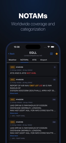
NOTAMs
Active NOTAMs for any airport worldwide, categorized and keyword-highlighted so critical items — runway closures, TFRs, navaid outages — stand out from routine notices.

FAVORITES & HOME
Your favorites list shows each airport's decoded weather summary and civil dawn/dusk times at a glance, sorted by distance from your position. Organize favorites into custom folders — drag to reorder, or let any folder auto-sort by distance from you. Pull to refresh, swipe to remove, or long-press to open directly in the map.

UNITS & SETTINGS
Fully configurable: temperature (°C/°F), wind speed (kt/mph/m/s), altimeter (inHg/hPa), visibility (SM/km), and elevation (ft/m). Light and
dark theme. Minimum runway length filter to declutter thee.

IPAD
Adaptive layouts throughout — master-detail home screen, navigation rail, and a collapsible map sidebar with layer controls.

AeroWX Pro unlocks the full app after a 21-day free trial. Subscribe monthly or annually — cancel anytime. AeroWX is ad-free, whether or not you subscribe.

Terms of Use (EULA): https://www.apple.com/legal/internet-services/itunes/dev/stdeula/