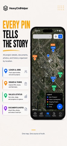
Stop overcomplicating your life with spreadsheets. HeavyCivilHelper is for work tied to physical locations: civil contractors, outside sales, utilities, and more. Designed for the field coordination layer: geographic, real-time, and phone-first. Pin every RFI, directive, change order, and lead to a GPS coordinate. Know what is open, where it is, and who needs to act on it. Built alongside real construction workflows and field sales operations, HeavyCivilHelper helps contractors, canvassing teams, inspectors, field crews, and operators understand activity geographically and coordinate work visually.

USE CASES:
• Lead Tracking
• Territory Management
• RFIs & Directives
• Field Issue Tracking
• Route Planning
• Construction Coordination
• Punch Lists
• Canvassing Operations
• Sales Territories
• Project Variable Tracking

FEATURES:
• Interactive map-based workflows
• Lead and project pins
• Territory visibility
• Route planning
• Overdue lead highlighting
• AI-assisted operational organization
• Field photos and attachments
• Mobile-first field coordination

HeavyCivilHelper treats the map as the primary organizing system — not just a secondary feature.

If your work happens geographically, HeavyCivilHelper was built for you.

Intended for professional and operational use by adult users and field teams.